Multimodal Transportation District or the (MMTD)
In April of 2009, the Tallahassee/Leon County Multimodal Transportation District became effective for the central area of the City. The goal is to facilitate the use of multiple modes of transportation, leading to a reduction in automobile use and vehicle miles traveled. But a Multimodal District addresses more than just transportation - by adopting such a district, the community recognizes that mixed uses and well-designed buildings & public places are just as important as providing transit, bike paths, and sidewalks.
According to the Florida Department of Transportation, "a multimodal transportation district is an area where primary priority is placed on assuring a safe, comfortable, and attractive pedestrian environment, with convenient interconnection to transit...Common elements include the presence of mixed-use activity centers, connectivity of streets and land uses, transit-friendly design features, and accessibility to alternative modes of transportation."
A Multimodal District is created through adoption of an amendment to the Comprehensive Plan, and allows mitigation fees from development to go toward transit, bicycle, and pedestrian projects rather than road widening. This is important in the core of Tallahassee because there isn't room to widen many roads, if any, without destroying parts of the community.
The District
Full-size PDF of the MMTD map
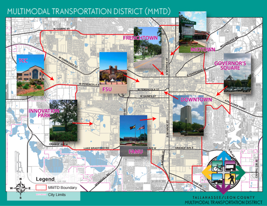
The MMTD comprises an 18.2 square mile area in central Tallahassee and includes the Florida State Capitol Complex, Downtown, Frenchtown, Midtown, the Monroe-Adams District, Florida A & M University, Florida State University, Tallahassee Community College, Innovation Park, and Governor's Square Mall, among many other destinations. Within this District, the City of Tallahassee and Leon County have partnered to create a safe and desirable environment for pedestrians, cyclists, and transit users through:
- Mixed-uses to support walking and cycling
- Densities to support transit
- Interconnected streets and paths
- Good urban design
Development within the MMTD is guided by the MMTD Code, with a goal of creating places for people. The Code seeks to improve the urban fabric of the Capital City through an increased emphasis on urban design and the public realm, thereby creating a pedestrian-friendly and transit-supportive district. To learn more, visit MMTD Code.
Concurrent with the establishment of the MMTD, the City and Leon County partnered with the Florida Department of Transportation to establish a program to fund active transportation improvements that allows mitigation fees from development to go toward transit, bicycle, and pedestrian projects rather than road widening. This is important in the core of Tallahassee because there isn't room to widen many roads, if any, without destroying parts of the community. To learn more, visit Significant Benefit Program.
The Plan
Implementing the Multi-Modal Transportation District Plan

The MMTD Code covers all areas within the MMTD, including our downtown. The code seeks to improve the urban fabric of the Capital City through an increased emphasis on urban design and the public realm, thereby creating a pedestrian-friendly and transit-supportive district. The standards will:
- improve urban design along Gaines Street,
- increase bicycle and pedestrian mobility,
- improve pedestrian comfort with more street trees,
- promote in-town amenities and destinations,
- ease restrictions to urban infill, and
- support the efforts of StarMetro, the city's bus transit system.
The new development standards in the MMTD Code reflect public comments voiced in the past several years, namely in various sector and neighborhood plans, calling for increased attention to urban design and bicycle and pedestrian mobility.
What development standards apply to my project?
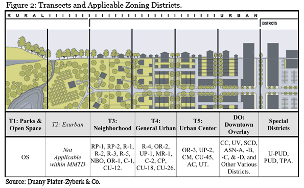
Permitted uses for proposed projects within the MMTD are found in the zoning districts. Based on densities and intensities, the zoning districts are organized under the appropriate Transect, as shown below. Development standards are established for the Downtown Overlay and one of the three Transects. Once you've determined which Transect your site falls within, simply follow the standards listed in the MMTD Code.